August 29, 2008 -- Since Hurricane Katrinaĺs landfall three years ago, the communities of the Gulf Coast have approached planning and development in a variety of ways. Here, we take a look at some noteworthy efforts and their progress to date. Also, donĺt miss the SunHeraldĺs city-by-city report from August 24, 2008, which can be found here.
Bay St. Louis
PlaceMakers, LLC continues to work on Bay St. Louisĺ Architectural Guidelines and Subdivision Regulations, reports Susan Henderson with the firm. As of Aug. 22, 2008, the architectural guidelines were 95 percent complete, with a target completion date of mid-September. The subdivision regulations are 70 percent of the way toward completion; Henderson hopes they will be finished before the holiday season.
DĺIberville
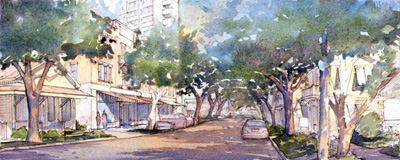
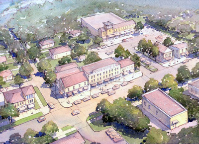
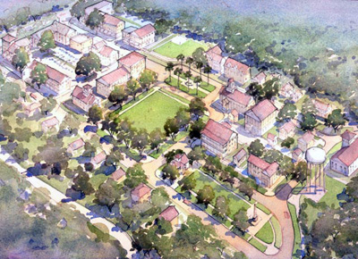
A preliminary SmartCode for DĺIbervilleĺs historic downtown area and its surrounding neighborhoods was developed by Jaime Correa and Associates in collaboration with the City of DĺIberville Planning Commission, Jeff Taylor and Deonne Olier from the Planning Department, and the general public. The consultantĺs fees were paid with a Community Development Block Grant awarded by the State of Mississippi last December. The final version is posted in the Cityĺs Internet home site; it will be submitted for approval to the City Council in July.
In parallel to the production of the SmartCode, the firm of consultants has been developing site-specific architectural guidelines. The report is modeled along the same lines as Urban Design Associatesĺ (UDA) ôA pattern book for Gulf Coast Neighborhoodsö; this new set of architectural guidelines capitalizes on specific areas of the master plan, identifies the character of public spaces, refines the architectural production of domestic and civic buildings, and defines a precise character for the massing reduction of hotels and casinos. The architectural guidelines will be approved in tandem with the final version of the historic downtown SmartCode.
Meanwhile, Bridge and Watson, a planning firm from Jackson, Miss., is amending the existing comprehensive plan and producing an updated version to suit the new annexation area north of the City. This process may take a few more months than the implementation and approval of the SmartCode and architectural guidelines. The City Council may approve it, in principle, at the end of summer 2008.
Additionally, Zimmerman and Volk Associates produced a revealing Residential Market Potential report for the downtown and redevelopment areas within the City of DĺIberville. Their target market methodology identified a development potential for almost 1,000 units within the historic downtown. The report spurred the creation of two citizen-based groups: the Central Avenue Task Force and the Downtown Housing Development Committee. The former group, composed of various property owners, developers, local architects, and public officials, has been charged with the coordination of visioning and development efforts along one of the main spines of the City; the other is a housing effort focused on the production of affordable housing and mixed-use buildings within the geographic downtown area.
According to Jeff Taylor, director of development, ôdespite difficult economic times, the development community and the gambling industry shows resilience and interest in the results of the process.ö A casino site has been committed and approved by the State of Mississippi, a new suburban Target Superstore broke ground at the intersection of I-110 and I-10, a Minor League developer initiated negotiations to locate a small stadium within the confines of the city, the Gulfport Aquarium is aggressively looking a relocation site within the downtown area, a South Florida development group has shown interest in the reconstitution of the historic Main Street in downtown, and the reconstruction of housing areas continues its steady development.
Gautier
Jeff Wilkinson, Gautier councilman at large, reports that the city didnĺt have to replace any government buildings after Katrina hit, but the cityĺs senior citizens center was flooded. That facility is now being repaired and should re-open before the end of 2008.
Gautierĺs City Hall, which is split between two buildings -- North (main building) and South (planning and utilities) -- seemed to be mostly undamaged after the storm. City Hall North, for example, sustained some damage, but was and remains functional. Recently, however, previously unnoticed damage was discovered in City Hall South, which may need to be replaced if the current investigation uncovers damage that makes more than 50 percent of the building uninhabitable. If the damage falls below that threshold, the city will use donated funds from other cities and groups to finance the repairs.
As for the cityĺs residential neighborhoods, most of the damaged homes have been repaired and people are back in them. In the coastal regions, however, there remain about 100 homes that havenĺt been rebuilt and are still vacant. Wilkinson believes low insurance-settlement figures and cost-prohibitive insurance figures after rebuilding are to blame.
The city currently is moving through the approvals process for a $5 million CDBG grant aimed at downtown revitalization. ôWe donĺt have a traditional downtown; weĺre more of a highway community,ö says Wilkinson. ôSo weĺve struggled with the downtown issue. A lot of the things the SmartCode prescribes were tough to fit with our realities.ö
The grant will give Gautierĺs downtown area a facelift, says Wilkinson, providing funds for several miles of a 10-ft.-wide, multipurpose path; crosswalks on Hwy 90; and median landscaping. Originally, the grant was designed to aid redevelopment of downtown buildings statewide, but it was scaled back to address less expensive, cosmetic improvements.
Gautier currently is working on a new comprehensive plan and updating its ordinances. ôOur approach may not be a strict SmartCode, but weĺre trying to incorporate components of it into the comp plan and ordinances, to address the desires of some of our residents,ö says Wilkinson. The comprehensive plan should be ready for its final review by the end of September 2008.
Wilkinson also reports a new water and sewer project in the northern part of the city, which is funded by a $4.5 million CDBG grant aimed at improving infrastructure. ôBecause that area is north of I-10, itĺs become a more attractive area for new homes, so we were able to get the water and sewer upgrades up there to accommodate the growth in that area,ö says Wilkinson.
Statewide, the sales tax spike caused by Katrina rebuilding efforts seems to be over, says Wilkinson. ôOur sales tax levels have plateaued, so weĺre tightening our belts.ö
Gulfport Jones Park Improvements
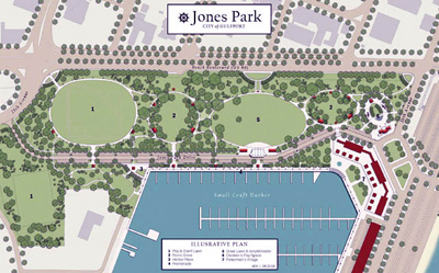
Working with the Friends of Jones Park and the City of Gulfport, the team of HDR, Guild Hardy Architects, and Brown & Mitchell, Inc., are preparing final designs for Jones Park, the cityĺs 30-acre waterfront park and regional center for public events and activities. Building on plans and studies prepared during the Renewal Forum, HDRĺs design calls for an outdoor amphitheater for large-scale concerts and special events; a promenade along the small craft harbor; a childrenĺs play area with splash fountain and new playgrounds; new pathways lined with shade trees, benches, and pedestrian-scaled lighting; open lawns for casual play; and picnic groves for family gatherings.
This final plan for Jones Park in Gulfport has been approved by Friends of Jones Park, and includes a new amphitheater and great lawn, promenade along the harbor, childrenĺs play area, and picnic groves. Image courtesy of HDR Design.
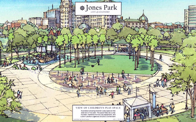
This view of Gulfportĺs Jones Park Childrenĺs Play Area looks north from the park toward downtown Gulfport, and shows the childrenĺs play fountain and lawn, maritime-themed play equipment, and picnic pavilion. Image courtesy of HDR Design/Rendering by David Carrico.
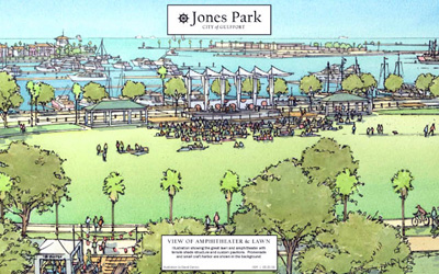
Gulfportĺs Jones Park Amphitheater and Great Lawn. This view looks southeast from Jones Park toward the harbor, and shows the great lawn, amphitheater structure, and promenade with the reconstructed small-craft harbor in the background. Image courtesy of HDR Design/Rendering by David Carrico.
Downtown Streetscapes
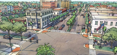
HDR is working with Main Street Gulfport to prepare streetscape designs for a 15-block area of downtown damaged during Hurricane Katrina. The design work includes roadway narrowing and boulevard restoration on the Cityĺs traditional ôMain Streetö, 25th Avenue; boulevard restoration on 13th Street; and the reconstruction of sidewalks and streetscapes throughout downtown. As part of the project, the City will install curb extensions at key intersections, new benches, trash receptacles, street trees, and pedestrian lights.
View looking north along 25th Avenue (US 49) in Gulfport. This rendering shows the proposed redesign of 25th Avenue with restored median, widened sidewalks, improved pedestrian crossings, conversion of angle to parallel parking, and removal of continuous right turn lane. Image courtesy of HDR Design.
Comprehensive Plan
HDR, working with Hall Planning and Engineering, Economics Research Associates, and Linda Weil, is preparing an update to the Cityĺs comprehensive plan. The process, organized around a series of visioning and planning workshops, will provide direction for rebuilding along the coast, infill and revitalization in existing neighborhoods, and the pattern and character of new development north of I-10.
West Side Community Plan
HDR has been selected to prepare the West Side SmartCode Community Plan. The plan will guide rebuilding of historic neighborhoods west of downtown Gulfport.
Town planner Kevin Klinkenberg reports his Kansas City, Mo., firm, 180░ Urban Design + Architecture is consulting in Gulfport regarding implementation of the SmartCode in some of the cityĺs existing neighborhoods.
Townwide, however, the SmartCode is struggling to find supporters, reports planner Jeff Bounds. One Gulfport neighborhood -- the West Side Neighborhood -- is forging ahead with a Community Plan, however.
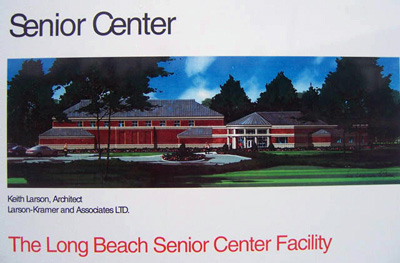
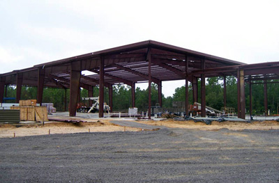
Long Beach
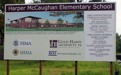
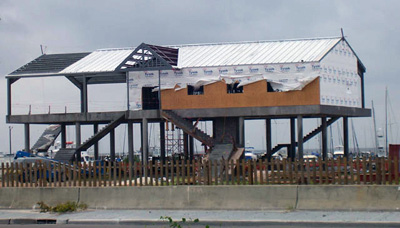
Long Beach Ward 5 Planning Commissioner Jacquie Lipski reports the city has broken ground and started construction of the Senior Center in the northern part of town. In addition, Long Beach also has broken ground for the new Harper McCaughan elementary school. It will replace the school destroyed by the storm in the downtown area. The school itself will be built in a different location -- farther north -- because of a lack of affordable insurance to rebuild the school in its original location downtown, on Jeff Davis Avenue. The Port Commission is overseeing the rebuilding of the Long Beach Yacht Club along the beachfront.
An artistĺs rendering of the Long Beach Senior Center Facility. Photo by Jacquie Lipski.
A view of the current construction of the Long Beach Senior Center Facility. Photo by Jacquie Lipski.
Photo by Jacquie Lipski.
The Long Beach Yacht Club currently is under construction. Photo by Jacquie Lipski.
Plans have been drawn up to replace the City Hall building on Jeff Davis Avenue; however, the existing City Hall still needs to be demolished. The drawings for the new building are beautiful; hopefully, once constructed, it will give the downtown the boost it needs to attract new businesses.
There are a few beachfront, low-rise condominium projects in the works, as well as a planned beachfront Holiday Inn that has yet to break ground. The Baptist Church, which was originally near the beachfront, has finished construction, again in a new, farther-north location. Plans have been drawn to rebuild the Long Beach Episcopal Church, which was also originally located beachfront; however, it also will now be rebuilt in a more northern location, next to the Long Beach Baptist Church. Plans are still under way for St. Thomas Catholic Church to rebuild on its original beachfront location in Long Beach.
Newly constructed condominiums have been built on and near Long Beachĺs beach front. Photo by Jacquie Lipski.
Newly constructed condominiums have been built on and near Long Beachĺs beach front. Photo by Jacquie Lipski.
Photo by Jacquie Lipski.
A few businesses have returned, but there remains a lot of vacant properties, both residential and commercial, along the beachfront area. The impact of the vacant properties is being felt strongly by the city. Property tax revenues are significantly down. The Long Beach School Administration is requesting a property tax increase to help fund the cityĺs schools. Insurance costs continue to be a barrier that most people simply cannot overcome at this time, thus severely limiting the cityĺs ability to generate tax revenue. Until insurance becomes more affordable, the development of beachfront and surrounding areas will remain very limited and out of reach for most individuals.
Photo by Jacquie Lipski.
Photo by Jacquie Lipski.
Moss Point
Moss Point has adopted a SmartCode resolution and is considering a formal SmartCode ordinance.
Ocean Springs
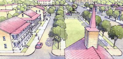
The Ocean Springs Planning Commission and Board of Aldermen have recommended and approved a special use permit for the development of the Ocean Springs Cottage Square. On a two-acre plot at 2151 Government St., the Mississippi Alternative Housing Program can now build a mixed-use model project with permanent affordable housing, a pattern for other communities to follow. This is the first time the Mississippi Cottages will be gathered in a neighborhood setting.
The Katrina Cottage Group and architect Bruce Tolar have owned the land for more than two years and view the development as a model for how these cottages can be used.
Government Street, on which the Square is sited, is a commercial corridor that intersects with the main street in Ocean Springsĺ historic downtown a half-mile to the east. Also within half a mile is the Bay Beach; several restaurants, bars, and coffee shops; a bakery; and a variety of retail. Within the quarter-mile pedestrian shed of the Square are a full-size grocery store, a school, and the YMCA (with a child daycare center). There also will be a Tolar-designed bus stop within a few hundred feet of the Square.
The Square is a private development, with Tolar and partners as the developer. At full build-out there will be up to 19 structures. Mixed-use, mixed-scale cottages will be included -- all in the Katrina Cottage design mold -- ranging from a studio-sized Steve Mouzon design to two-story models greater than 1,000 square feet.
Currently, there are four cottages on permanent foundations: Marianne Cusatoĺs original Katrina Cottage, the original Loweĺs cottage, and two Bruce Tolar designs. Three of the four are occupied by businesses: Tolarĺs architecture firm, Susan Tolarĺs real estate office, and a beauty salon renting the steel-framed Tolar design. Itĺs likely that the original Katrina Cottage will be occupied by a nonprofit housing organization that matches Katrina victims with rental housing.
By the anniversary of the hurricane on Aug. 29, the Square should double in size, with four of the eight Mississippi Cottages (inspired by Katrina Cottages and designed by a Mississippi team of architects as FEMA trailer alternatives) on new foundations. The other four could be delivered within a week or so of the first four.
Foundations are in for two more model cottages, both designed by Steve Mouzon and sponsored by BluWood and Ocean Springs Lumber. And two more -- both modulars -- are planned in the next six months. So by the end of the year, the Square should have 16 units in place, all occupied by residents and commercial clients. The three remaining will be the Tom Low-designed Learning Cottage (which could be a design charrette center and community meeting place) and two commercial units that likely will house small-scale retail (coffee shop, book store, restaurant, etc.)
Itĺs taken three years, but the Square finally represents one of the more ambitious dreams of the Mississippi Renewal Forum: An infill neighborhood of safe, appealing cottages to demonstrate the TND approach and the livability of small-scale homes in a real mixed-use cluster. Not only is it the first Katrina Cottage neighborhood on the Coast, itĺs the first anywhere.
The crucial last-step toward realizing this dream was the unanimous decision of the Ocean Springs Town Board to grant permission for residential occupancy on the first floor of units in this zone. That enabled the state to provide the eight Mississippi Cottages for rentals. Ocean Springs deserves praise for allowing these Mississippi Cottages to come off their wheeled delivery systems and onto permanent foundations. This is a permanent Ocean Springs neighborhood now and likely will set a standard for cottage neighborhood design in the TND mold.
In other Ocean Springs news, town planner Kevin Klinkenberg reports his Kansas City, Mo., firm, 180░ Urban Design + Architecture, is working with PlanningWorks on a new comprehensive plan and Unified Development Code (UDC) for Ocean Springs. The UDC will incorporate a form-based code district. Ocean Springs also has a new mixed-use building under construction downtown -- and almost complete.
Downtown Ocean Springs has been coded by Dover, Kohl & Partners; a Waterfront Plan has been developed by Torti Gallas. The city is now going through a Comp Plan process with Planning Works.
Ocean Spring residents continue to work with urban designers to fine-tune the vision for the city while beginning to lay the regulatory groundwork necessary to implement new urban principles.
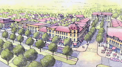
Dover, Kohl & Partners and Torti Gallas and Partners have been involved in jointly producing the Downtown Plan and the Front Beach Plan. The two firms led the Ocean Springs Design Forum for Front Beach and Downtown Ocean Springs from March 10ľ14. The public input portion was well attended and highly successful. The team then synthesized the many ideas heard from the community throughout the week into a single cohesive Master Plan. The planning team also created a series of computer visualizations, diagrams, drawings and detail plans that clearly illustrated the concepts of the Master Plan for the community.
In this rendering of the proposed redevelopment of Bienville Boulevard in Ocean Springs, Miss., mixed-use development is encouraged, with slow-moving side-access lanes. Image courtesy of Dover Kohl & Partners.
The entrance to downtown Ocean Springs is emphasized by a new community green space along Bienville Boulevard. Image courtesy of Dover Kohl & Partners.
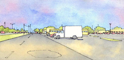
A street-level rendering of Bienville Blvd. in Ocean Springs, showing its current form, with an emphasis on auto travel and large, surface parking lots with the buildings set back far from wide, high-speed streets. Image courtesy of Dover Kohl & Partners.
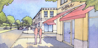
A street-level rendering of Bienville Blvd. in Ocean Springs, which shows a proposed redevelopment form: mixed-use buildings; pedestrian scale; tamed, walkable streets; and more than one mode of transportation. Image courtesy of Dover Kohl & Partners.
New buildings on potential development sites form a more complete street wall on Washington Avenue in Ocean Springs. Image courtesy of Dover Kohl & Partners.
Broomeĺs Grocery is an important staple within the Ocean Springs community; the design for its redevelopment includes substantial improvements to its siting and helps make it a more pedestrian-friendly environment. Image courtesy of Dover Kohl & Partners.
The proposed design for Ocean Springsĺ Ferson Optics site provides a range of uses and activities. Image courtesy of Dover Kohl & Partners.
State Street in Ocean Springs currently lacks some of the elements necessary for good urbanism, such as street trees and sidewalks. Vacant lots make the streetscape uneven and less inviting for pedestrians. Image courtesy of Dover Kohl & Partners.
New homes are built on vacant lots and street trees and sidewalks are added to State Street in Ocean Springs, creating a more pedestrian-friendly street. Image courtesy of Dover Kohl & Partners.
Planning Works engaged the community during the week of June 2ľ7 with a Community Design Forum that begins the first steps toward updating the cityĺs Comprehensive Plan. The Comprehensive Plan will become the guiding document for the future of Ocean Springs. Thus far, the community response has been positive as Planning Works moves ahead to implement the ambitious post-Katrina vision.
In other news, Ocean Springs has received a grant from the Federal Highway Administration valued at approximately $1.3 million for repairs to selected federally designated highways.
The Hurricane Katrina-related grant will repair any subgrade failures and overlay asphalt to portions of several city streets. The grant also will cover repairs to the bridge approaches at Davis Bayou and Heron Bayou.
ôThis project will allow us to overlay those city streets that were inundated in Hurricane Katrina,ö said Andreĺ Kaufman, Director of Public Works, City of Ocean Springs. ôThis cost was not eligible under FEMA guidelines, and we are pleased that the Federal Highway Administration has stepped to the plate.ö
Funding to begin this project is expected in the current fiscal year.
Pascagoula
A new Pascagoula Senior Center is being designed, and construction is planned for early 2009. It will be located on a portion of an 18+ acre site that was purchased by the City of Pascagoula in 2008 with MDA grant funding and CDBG Entitlement grant funding. This project is one piece of the culmination of a revitalization of a previously blighted area into a thriving community services area.
The Heinz property is in the process of preparation for demolition. Bids were received early in August 2008 and are being evaluated. Purchase of the land from the County was made possible through MDA grant funding, along with demolition and some infrastructure improvements to the site. This land will be used for the revitalization of the riverfront. The City of Pascagoula is committed to reinvigorating the riverfront into a mixed-use commercial and residential development. Seven acres of the riverfront are programmed for a combination of shopping, dining, hotel, convention, condominium, and entertaining opportunities. A streetscape project is planned with additional MDA grant funds to connect a downtown thriving with new life to the riverfront area.
Property acquisition has been proceeding this year to support a new boat launch under the High Rise Bridge and the associated historic pathways project. The pathway will provide pedestrian access to many of the new and old sites in the downtown area.
Skate park bids have been accepted and construction should be under way by the end of August 2008. The projected completion date is the end of October 2008.
Improvements have been made at the soccer complex to meet the Americans with Disabilities Act (ADA) requirements and to improve lighting for the fields.
Huge anchors have been placed around downtown. They are located at the lawn in front of Emmy Jacks and the Spy Shop on Delmas, the library on Pascagoula Street, and the parking area west of the Ritz building downtown. High school students are being asked to paint the anchors in creative ways. The three anchors were donated when the Naval Station Pascagoula closed.
Cottage Village Development: Sixteen cottages were approved by the City Council for development into a village on Delmas at Frederic Street. The village will be developed with adequate parking and an attractive green space area for residents to gather, rest, and enjoy the benefits of the area. For two years, they will be used for a mixture of residential and shopping space, with first availability going to housing residents affected by the storm. After two years, the cottages will be transformed into a shopping village area.
The City of Pascagoula has been working with the Corps of Engineers during 2008 to develop a plan so the City will get an enhanced beach along Beach Blvd. The landscaped beachfront will be supplemented with a promenade. The addition of the beach itself will offer protection from future storms by providing an area for waves to dissipate before reaching the roadway and adjacent homes.
The historic train depot that houses a local art gallery reopened in early 2008.
The Splash Pad at Beach Park opened this year, and the City of Pascagoula has continued with its beautification efforts by planting 1,139 new trees.
The City has plans to restore the old Pascagoula High School under the guidelines of the Department of Archives and History. The restored building, called Bayside Village, will provide apartments for the elderly with various levels of assisted living needs.
The beach pier was re-opened this year, in time for Memorial Day, built with concrete piles and a new cable rail system. The new construction should make this pier more resistant to future storm events, while providing an attractive location for families to gather and for visitors to fish.
Pascagoulaĺs Public Works office building was re-opened after Katrina repairs this year. The office is located on 14th Street, and the re-opening of the facility allowed its employees to move out of a temporary building and back into their permanent building.
Road Improvements in Pascagoula:
The Following roads are being repaved and repaired in Pascagoula as part of the cityĺs annual program in cooperation with the County:
Verdon St., Watts Ave., 14th and Old Mobile, City Park St., Amonett St., Communy Ave., Corinth St. and Duncan St., Middle Ave., Poitevin St., Wilson Ave., Mercier Ave., Baptiste Ct., Veterans Blvd., Dunham St., Kenneth Ave., Criswell Ave., Dogwood Ave., Redwood St., Warren St., and Frederick Street.
In addition, several roadway improvement projects are nearing the end of the planning stage and will be moving into construction in the months ahead:
Beach Boulevard: Road improvement plans have been submitted to the Mississippi Department of Transportation (MDOT) for final review and approval. The hurricane-damaged boulevard is receiving much-needed improvements. Repairs will be made to the seawall, curbing and sidewalks. Beach Boulevard will be repaved and the lighting will be restored. Pending any unforeseen setbacks, construction will start in November or December.
Ingalls Avenue and Pascagoula Street: The combined hurricane repair and infrastructure upgrade project for Ingalls Ave and Pascagoula is coming to fruition. Pascagoula St. from Beach Blvd. to the city limit of Moss Point will be repaved and repaired. Ingalls Ave. will be repaired from 14th St. East. MDOT determined that Ingalls Ave. and Pascagoula St. have been heavily damaged following Hurricane Katrina due to high traffic volume, excessive loads, and truck traffic from debris removal. Federal funds are paying for the repairing and repaving of the two roads. Local funds are being used to replace the old or damaged water, sewer, gas and storm drain pipes. Video camera technology is being used to identify damaged pipes that need repair or replacement.
This project also includes beautification efforts by the city. The beautification efforts will improve traffic flow and appearance at the intersections of Jackson Ave, Krebs Ave., and Live Oak Ave. Decorative lights and landscaping will be introduced to enhance the appearance and perception of Downtown Pascagoula. Due to the magnitude of the project, construction will not start until summer or fall of 2009. The survey for these projects is complete, and design of the roads is well under way.
Pass Christian
The regulating plan for the final quarter of the town, the long-awaited North Central Community Plan, has been submitted to the Planning Commission for comments and adjustments preparatory to public hearing for adoption. Once adopted, this will leave Pass Christian as one of the first towns in the country to replace its existing zoning entirely with a SmartCode citywide. The town currently is drawing up new Subdivision Regulations that tie directly into the SmartCode; Pass Christian adopted the SmartCode, a compatible Comprehensive Plan, and Community Plans covering three quarters of the town in spring 2008.
The town currently is the most advanced on the Mississippi Coast, with respect to adoption and implementation of the SmartCode. The townĺs Planning Commission, Zoning Board of Adjustments, and Historic Commission have embraced the new code enthusiastically and have enforced the codeĺs intent during the past few months.
The city is still in recovery, and the recent economic slowdown has affected rebuilding somewhat, but both the East Pass Village area (where the Wal-Mart will be rebuilt at the center of a SmartCode neighborhood center) and the Downtown Pass area are bright spots. A new redevelopment effort focused on the downtown has joined the interests of resident advocates and of local developers and downtown property owners, who frequently found themselves on opposite sides of issues during earlier planning efforts to determine density and height limits. The groups have united behind the cityĺs new SmartCode Downtown Community Plan and are aligned with the common interest of rebuilding a vibrant, walkable, Gulfside downtown with great, energetic, retail main streets around a core of small-lot, single-family residential neighborhoods nested in the very large old blocks arrayed along the bluff overlooking the Gulf.
Hancock County
Hancock County currently is wrapping up its comprehensive plan.
Harrison County
In July, Harrison County adopted its new Comprehensive Plan and Sand Beach Master Plan. According to the countyĺs Web site at www.planharrisoncounty.org, the Harrison County Comprehensive Plan update accomplishes four main objectives:
It defines the 30-year realistic and achievable vision for Harrison County.
It brings direction and policies for the county and coordinating agencies.
It coordinates decision-making with agencies across the county.
It provides predictability for landowners, businesses, and residents as the county develops over time.
The County currently is under way with its ordinance revisions, which are expected to be complete at the end of the year. Continuing coverage and more images related to planning efforts in Harrison County can be found at www.planharrisoncounty.org.